
The answer is obviously not, but many in Indonesia were convinced that Lidar is the method for measuring peat extent and thickness. Where does this come from?
Lidar, particularly used in airborne mapping, can be used to create a 3-D earth’s surface model. Laser pulses reflect objects both on and above the ground surface, thus it enables estimation of both ground surfaces and aboveground objects such as trees. It is mostly useful for estimating tree biomass, and thus above ground C stock. “Ground points” can be extracted using some algorithm to create a DTM (digital terrain model).
However in Indonesia, Lidar becomes a technology for mapping everything. Google Lidar Indonesia and you can find various consultants flying Lidar in Indonesia. Even NASA has a joint project using Lidar for mapping forest C stock in Kalimantan https://carbon.nasa.gov/cgi-bin/inv_pgp.pl?pgid=732 (Applied GeoSolutions, one of the teams competing in IPP, is working with NASA on peat mapping).
As a saying goes “If you only have a hammer, everything looks like a nail”. Obviously remote sensing consultants need some work, and Lidar was sold as the hammer.
Are there any research on the use of Lidar for mapping peat?
There are several studies on peatland that used Lidar, mostly used to estimate the thickness of burn in peatland and Carbon loss can be estimated from pre- and post-fire Lidar. Examples are studies in Canada and USA. A study in Indonesia used post-fire Lidar to estimate ground elevation of burnt area. The pre-fire ground elevation was estimated from neigbouring un-burnt area. A more recent study proposed the use of UAV for generating point clouds for mapping ground elevation, which is low cost and interesting.
A study in Canada used both Lidar derivatives and Synthetic Aperture Radar for identifying peat using Random Forests.
So why and how Lidar is the only instrument heavily promoted for mapping peat extent and thickness in Indonesia? The idea is to locate the so-called peat dome, an elevated convex area of peat deposits. According to a peat expert in an interview “If you can pick out these domed structures, then you’ve got a fairly good idea of where your peatlands are located, regardless of whether they’ve got forest on them, plantation, scrub or whatever,” Susan Page, a geographer from the University of Leicester. A Dutch consultant company claimed that ground elevation derived from Lidar combined with an assumption that the peat “bottom” is around Mean Sea Level is a simple model to estimate peat thickness. And this particular model used simple linear model relating elevation to peat thickness. Unfortunately that simplistic model doesn’t work everywhere!
Well, you can pick out and estimate peat thickness above the ground, assuming you already know that there is a peat dome, but how about the massive amount of peat below ground surface? In our study, we actually show that the amount of peat (and carbon) outside the dome is as large as just in the dome.
Lidar certainly gives one of several covariates useful for mapping peat thickness, but to map peat thickness continuously, not just the dome (which is already known), you need other covariates, such as radar data, distance from river, etc. And the model should not be linear! In addition, most peatlands in Indonesia are in lowland areas, getting the absolutely correct elevation does not help much in making better models. We show repeatedly in here and here that using a 30m free SRTM DEM we can pick out the dome and map peat for the whole area, not just the dome. We should use our brain, and create better models than relying on a single technology.
Many Lidar flights been conducted in Indonesia, yet proper validation to show that the data can provide reliable estimates of peat are lacking. No scientific evidence.
If you like to learn more about the best and most cost-effective way of mapping peat, read it here. You can use Lidar as one of the covariates, if you can afford it, but the principle should be based on digital soil mapping.
It seems that well before the peat prize was announced, it was agreed that Lidar is the preferred methodology for mapping peat in Indonesia. Also read here and here. And of course DSM techniques were quickly dismissed by the Indonesian Peat prize judges without any scientific proof that other methods are better! The international jury members try hard to discredit our work, as they have have their own agenda on getting their mates to the final. How can 3 teams get into the final without having any results??
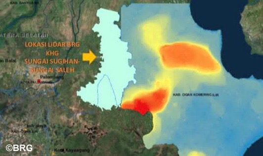
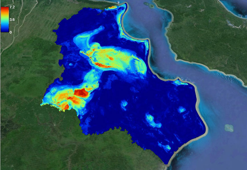
Let’s compare the result of BRG Lidar peat map (left) with our map for Ogan Komerang Ilir. We only used the free 30 m SRTM and we can show the same 2 peat domes and more details as we calibrate field observations with covariates, in this case elevation is the main predictor. Lidar is an expensive exercise just to show the dome.
Leave a Reply