Open Digital Mapping methodology is a cost-effective and science-based method for mapping peatlands in Indonesia. Peatlands in Sumatra, Kalimantan, and Papua have been mapped using field survey data combined with free remote sensing data and machine learning methods.
We recently published a critical review on digital mapping of peatland. We recommend that peatland is better mapped using field observations combined with more than one source of remotely-sensed data, such as optical and radar products. We called this digital peatland mapping, based on the Digital Soil Mapping concept.
In 2018, we (researchers from Sydney Uni and IPB) proposed the Open Digital Mapping methodology, which use open data in an open-source environment, as a cost-effective and accurate method for mapping peat and its carbon stock for large areas in Indonesia.
Our group at Sydney University is a pioneer in Digital Soil Mapping, which is outlined in our 2013 paper.
The open mapping methodology combines field observations with factors that are known to influence peat depth distribution in space. These factors are represented by multi-source remotely sensed data derived from freely-available open data: digital elevation model from corrected Shuttle Radar Topography Mission, geographical information, radar (ALOS PALSAR and Sentinel 1 data) and optical images (Landsat TM). The method makes use of advanced machine learning models to predict peat depth every 30 m on the land surface.
To make it transparent, accountable, and repeatable, all mapping procedures were scripted in the R open source and free software.
As the methodology is open (open data, and open-source), the method is scalable to the whole of Indonesia and can be done in parallel by many groups. With appropriate training, various groups in Indonesia can perform this mapping procedure in a standard, and objective way. This is an evidence-based approach.
Since then we (Sydney University researchers and collaborators in Indonesia) have applied the Open Digital Mapping methodology to map peatland in different parts of Indonesia. Peatlands in Sumatra, Kalimantan and Papua can be mapped accurately and cost-effectively.
Peatland in different parts of Indonesia have their own specific characteristic that required integrated data, such as underlain geology and soil, climate, topography, age, space and dynamic landcover. Thus it cannot be mapped just relying on a single remote sensing data such as Lidar (which does not map peat). It needs field observations combined with multisource and multi-temporal data combined with machine learning algorithms.
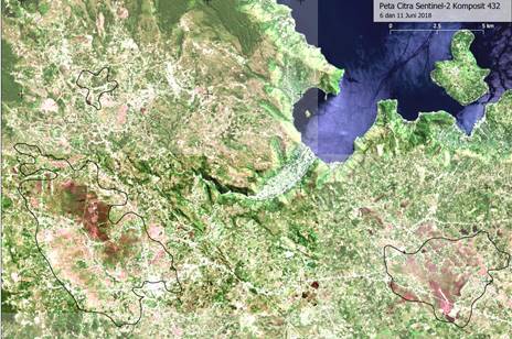
The following are areas in Indonesia that have been mapped using Open Digital Mapping technology, all maps are at 30 m resolution with uncertainty estimates. All methods are based on the best scientific methodology.
Pulau Bengkalis (Riau)
Mapping peat thickness and C stock on the western part of Bengkalis island ~50,000 ha using a combination of field observations and corrected DEM from SRTM and Sentinel 1 data.
Reference:
Rudiyanto, Minasny, B., Setiawan, B.I., Saptomo, S.K., McBratney, A.B., 2018. Open digital mapping as a cost-effective method for mapping peat thickness and assessing the carbon stock of tropical peatlands. Geoderma, 313, 25-40.
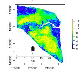
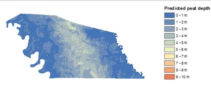
Ogan Komerang Ilir (South Sumatra)
Mapping peat thickness & C stock ~ 600,000 ha
Reference
Rudiyanto, Minasny, B., Setiawan, B.I., Arif, C., Saptomo, S.K., Chadirin, Y., 2016. Digital mapping for cost-effective and accurate prediction of the depth and carbon stocks in Indonesian peatlands. Geoderma, 272, 20-31.
Merang (South Sumatra)
Mapping peat thickness ~100,000 ha
Contact: Dr. Rudiyanto, University of Malaysia Terengganu.
Pesisir Selatan (West Sumatra)
Mapping peat thickness and C stock ~40,000 ha. Undergraduate students from University of Andalas participated in field data collection as part of their course.
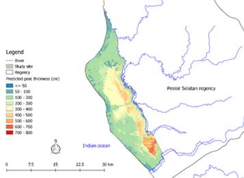
Contact: Prof. Dian Fiantis, University of Andalas.
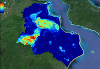
Pasaman Barat & Agam (West Sumatra)
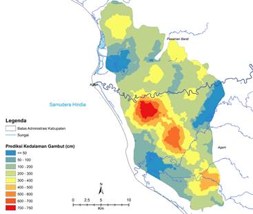
Mapping peat thickness & C stock ~50,000 ha. Peat dome can be located along 2 rivers, the domes are relatively flat in the landscape and cannot be identified using DEM alone.
Contact: Prof. Dian Fiantis, University of Andalas.
Kubu Raya (Central Kalimantan)
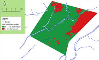
Mapping peat extent and depth class ~10,000 ha
Contact: Dr. Rudiyanto, University of Malaysia Terengganu.
Katingan (Central Kalimantan)
Mapping peat thickness & C stock ~80,000 ha
Reference
Rudiyanto, Minasny, B., Setiawan, B.I., Arif, C., Saptomo, S.K., Chadirin, Y., 2016. Digital mapping for cost-effective and accurate prediction of the depth and carbon stocks in Indonesian peatlands. Geoderma, 272, 20-31.
Papua
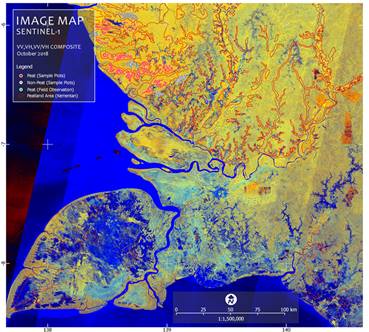
Mapping peatland extent and depth class based on limited accessible data using multitemporal Sentinel 1 and Sentinel 2 data ~2 Million Ha.
Contact: Dr. Wirastuti Widyatmanti, UGM.
Reference:
Wirastuti Widyatmanti, Budiman Minasny, Yiyi Sulaiman, Wahyunto, Deha Agus Umarhadi, Kurniawan Nugroho. 2019. Digital Tropical Peatland Mapping of Papua. PEDOMETRICS 2019 – University Of Guelph, Ontario, Canada, 2-6 June 2019.
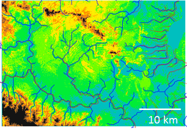
Toba Highland (North Sumatra)
One of the rare tropical highland peat (elevation 1400 m), next to Lake Toba. Area about 500,000 ha with materials derived from woody plants. Work in progress with research collaboration from Universitas Sumatera Utara and Universitas Gadjah Mada.
Leave a Reply